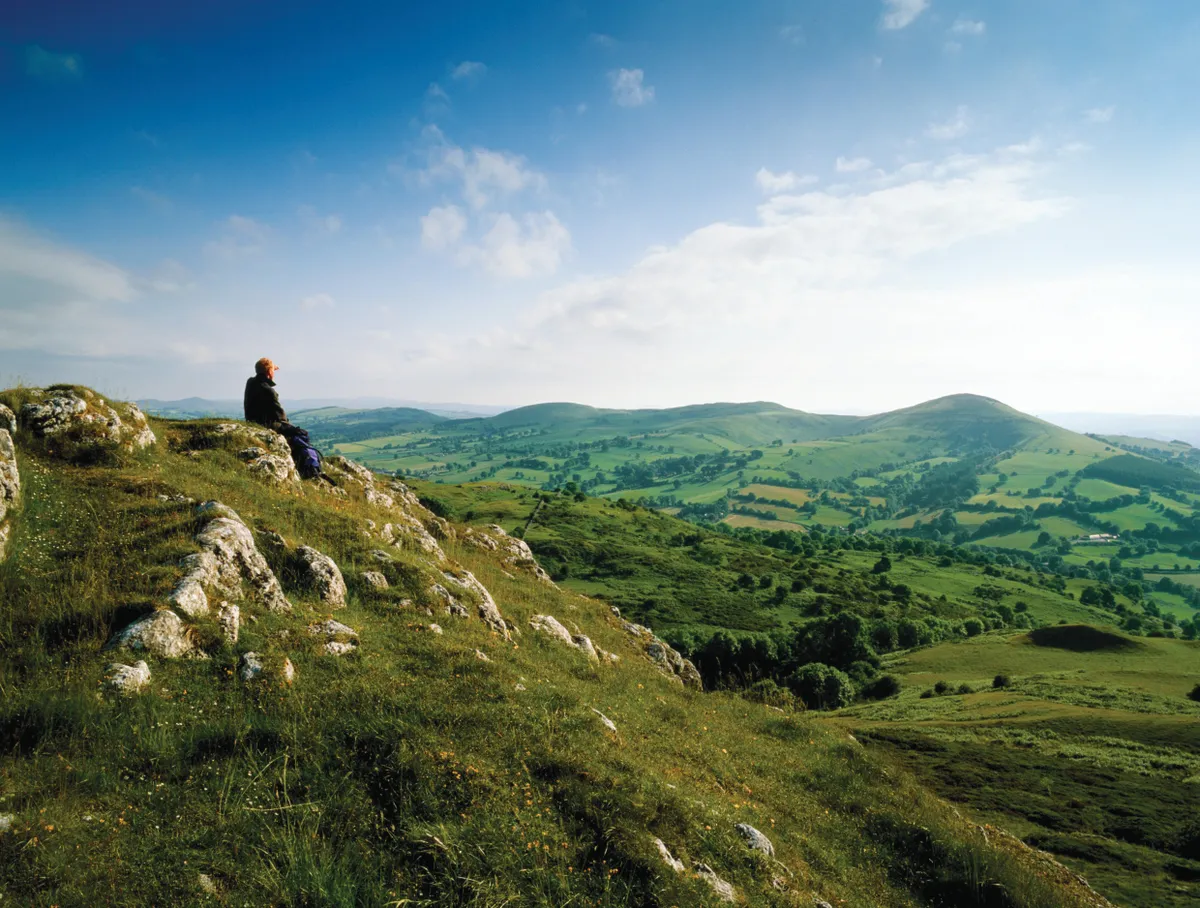
They crowd in, these cloud-skirmished hills. Some are conifer-black. Others have grass pelts from which rocks protrude like broken bones and ponds that glint on their summits. Quarries yawn. Raptors scream. Sheep scatter.
These are wild enough hills all right, even without their historical association with the Red-haired Bandits of Mawddwy – Gwylliaid Cochion Mawddwy, in Welsh.

Bandit in Snowdonia
The bandits were at large in the early 16th century after the Wars of the Roses, when territory between Powysand Meirionnydd was unclaimed and un-sheriffed.
Local historian and tour guide Arfon Hughes takes up the tale. “Some say they came earlier, even before Glyndŵr’s revolt. Villains expelled from their own communities were attracted to the area, and particularly to Dugoed (Black Wood) because there were so many trees to hide in. They were quite lawless in the fact that they were stealing herds of cattle and sheep in the daytime. Many of them had been trained as bowmen and they had hideouts in caves along the road between here and Dolgellau, so they could hijack travellers; the tops of these hills were like the main roads of Wales at the time.”
But eventually, 80 of the bandits were hanged by order of Baron Owain of Dolgellau on Christmas Eve 1554, and buried in Gors Goch. The following October, Baron Owain himself was ambushed and killed by the remaining bandits, who were later hunted down.
Dinas Mawddwy today
Now peace reigns, or so it seems. The Brigands Inn at Mallwyd, a 16th-century hostelry where the bandits apparently conspired, provides very good food and lodging. And the village of Dinas Mawddwy with its farm shop, Caffi-Crefft (a community enterprise), post office-shop and convivial Red Lion pub is characterful and charming. But were the bandits really all wiped out? “Well,” laughs Arfon, “who can tell?”
There is no easy route up Foel Benddin from Dinas Mawddwy. Other hills are available – for example, Arfon prefers gentler Foel Dinas, with its forest, lake and quarry. “Nobody climbs Foel Benddin,” he says, and I don’t entirely blame them – it’s tough. Nevertheless, it is also wild.

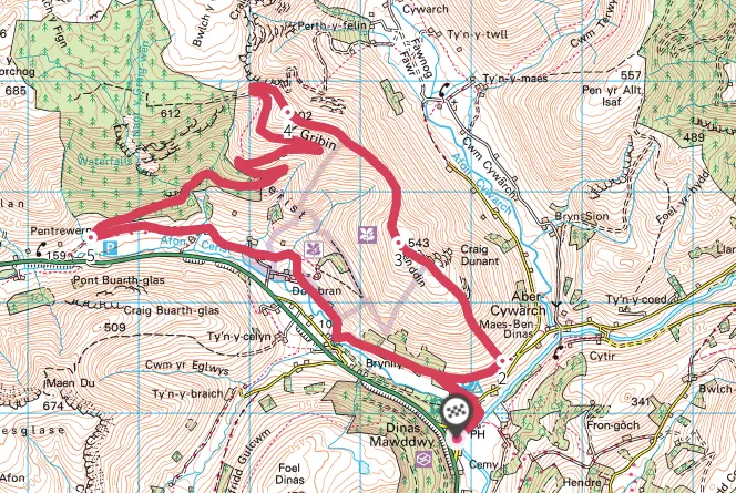
A challenging 9-mile hike from Dinas Mawddwy over the high hills of Foel Benddin and Y Gribin in Eryri (Snowdonia) National Park.
8.7 miles/14km | 5–6 hours | challenging
1. Tunnel tales
To climb Foel Benddin, first descend the steps opposite Ebenezer Chapel. See if you can spot trenches running down Foel Benddin.
Keeping to the River Dyfi, ignore the footbridge and circuit the common to the road. Cross it and take the footpath just right of the caravan site, then bear uphill through the trees to the bridleway. Go through the gate to your right, then continue to Ty’n y Pwll farm. “Now there’s a story I can’t verify,” Arfon tells me, “but the farmer claims his tractor sank into the ground here, and he found a tunnel going all the way to the summit.”

2. Up the trenches
Unless you find the tunnel, head straight up, with the ruined wall as a guide. The ground is rough with slithery scree and ankle-turning tussocks. Walking poles, good boots and good weather are advisable. Remember the vertical trenches? They are sled tracks, according to Arfon. “Local people would cut peat for their hearths from the bogs on the top, tie it to a sled and slide all the way down,” he says. This is not necessarily a reassuring thought on such a precipitous slope, but if you do slip, aim for the Red Lion.
Relax when the contours plateau. The summit is swampy, as the peat was cut from here. Star moss grows around a small pond, and meadow pipits flock in this elemental landscape of stonecrop, stonechat and stone walls.
3. High contours
Continue along the ridge. The hill is open-access land but lacks a waymarked path or stiles – look for well-disguised sections of fence that can be opened like gates. The views are splendid. To the south-west is the Dyfi Forest, a 6,000-hectare blend of commercial, public and private forestry. Nearer hills and Dugoed to the south-east are also wooded – this is where the bandits hid themselves. The Berwyn Range rises to the east and Aran Fawddwy to the north. Descend to the bwlch along the fenceline.
Climb again, passing Corun Braichmelyn for Y Gribin. Now ravens dominate, wheeling over Cwm Cywarch. Look out for jacksnipe, too, exploding from the tussocks.
4. Hairpin downhill
The hilltop narrows to a pass between Cwm Cywarch and Cwm Cerist. It’s a great place to watch ravens tumble, spot peregrines on the crags, hear water trickle and the tinkle of sheep-scuffed scree.
To turn your wild-hill walk into a wild-mountain walk, just continue up Glasgwm ahead.Otherwise, descend by the forestry track, hair-pinning down to your left. It enters Craig Wen Forest and passes the lowest of the Nant y Graig Wen waterfalls before the conifers give way to a broadleaf belt of birch, sycamore and rowan.

5. Above the afon
Turn left through the grounds of Pentrewern on to the bridleway. It’s not well waymarked, but generally keeps a contour or two above the River Cerist, crossing fields and hedged lanes.
Some of the farms are remarkable. Glance up-field to National Trust-run Braich Melyn, with its barn built from vast stones, then to your right pass Dolobran, a 17th-century farm with a woollen mill. Meanwhile, the family at Ty’n y Braich up the Maesglase valley can demonstrate 1,000 years of occupancy; they would have seen a bandit or two.
Eventually, enter Park Wood with its lovely oaks, soon emerging on the path above the caravan site. Cross the common back to the start.
Dinas Mawddwy, Foel Benddin and Y Gribin walking route and map