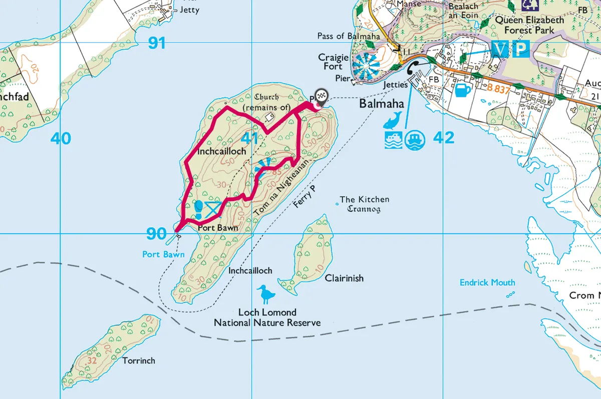
All of Loch Lomond’s 22 beautiful islands, and 27 islets, are divine in summer. Perhaps the prettiest island is Inchcailloch, at the south end of the loch.
It’s less than a mile long, with a superb lookout point, ancient ruins and an abundance of flora and fauna, and can be reached on a two-minute ferry ride from Balmaha. Once you’re there, a gentle walk leads across the island to Port Bawn (Port Bán), where a well-deserved swim awaits.

Inchcailloch walk
1.7 miles/2.7km | 1 hour | easy–moderate
1.Start
From Inchcailloch’s north pier, a path leads up through the woods. The trees were replanted some 200 years ago after their earlier decimation for their tannins, which were used to soften leather machine belts. The trees now form a roof over the island and, on sunny days, the path is covered in dappled green light. Butterflies add splashes of colour while birds, such as redstarts, woodpeckers, treecreepers and migrant warblers fill the air with sound. If luck is on your side, you may even get a sighting of an osprey.
After 200m take the first right turn; look right again for a side-path that soon appears. This leads to a ruined church and cemetery.

2. Religious ruins
An Irish missionary and the daughter of an Irish king, Saint Kentigerna settled here in the 8th century; Inchcailloch’s Gaelic name, which means ‘island of the old or cowled woman’ refers to this early holy preacher. She died onthe island in 743AD. A church was built here in the 12th century to honour Kentigerna and was in use until 1670 by the local people who rowed across for mass and to bury their dead. The last burial took place in 1947 and the church is now ruined.
Return to the path, which leads to the northern edge of the island, before making for the sheltered cover of Port Bawn in the south-west.
3. Beach bathing
At Port Bawn you’ll find an amazing beach with soft white sand. Its south-west aspect makes it a real sun trap. There are barbecue stands, too, and the swimming is safe in the cool, peaty water by the shore. You may need to pinch yourself to realise you’re in Scotland.
The return leads inland, rejoining the island’s main path. After about five minutes, take the first path on the right. This rises to the island’s highest point on Tom na Nigheanan. Watch for fallow deer foraging among the trees along the way.
4. Island peak
At 85m, the island summit might not be particularly high but it gives a magnificent panorama, more than justifying the effort to get there. It is arguably the best view you can enjoy of the loch. The other islands appear like green floating jewels, with the Munros Ben Lomond and Ben Vorlich to the north.
The path runs back into the woods and down to your starting point. Next to the pier back in Balmaha is the Oak Tree Inn, which has a beer garden and good food.
Inchcailloch Island walk
Inchcailloch walking route and map