With the possible exception of the A5 in North Wales, the Ridgeway may just be the most romantic road in southern Britain.
This 5,000-year-old path runs for 89 miles high over the prehistoric landscapes of Wiltshire and Berkshire to finish in the Chilterns. The sheer number of barrows, hillforts and other ancient sites mean that you don’t have to tax your imagination too hard to transport yourself to a magical, forgotten era.
The Ridgeway clings to the hilltops because these were once the only safe places to travel. The lowlands were choked with dangerous forests, swamps and flooding rivers. So early hunters and settlers chose the dryer heights for their droveways and trade routes.
This particular walk, near the start of the Ridgeway National Trail samples a section of the road from Avebury.
Looking for something a bit shorter? Try our 5.4-mile circular walk around Avebury to Silbury Hill and West Kennet Long Barrow.

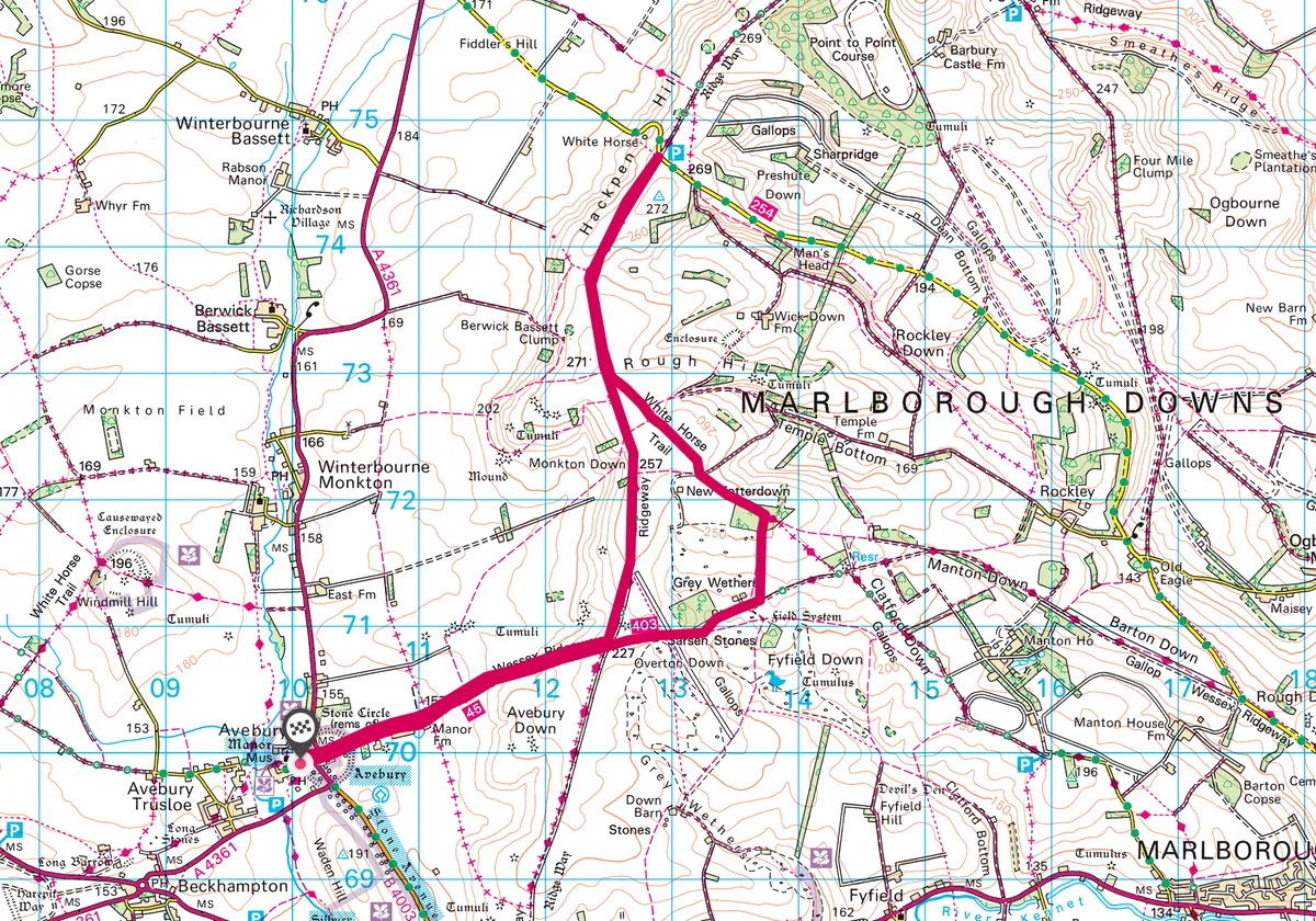
Avebury Ridgeway walk
9.2 miles/14.8km | 5 hours | moderate | 186m ascent
1. Avebury Stone Circle
Begin in the pretty village of Avebury, which sits within an enormous stone circle. Here you’ll find a few visitors and sheep nosing among the mighty stones and earthworks. This walk will show you where those stones came from.
Follow the path east out of the stone circle across the road from the Red Lion pub. You are now on the Green Street or Herepath. which is thought to have been an Anglo-Saxon military road. It enabled ninth century kings to speed their armies east to counter the threat of Viking raiders. Follow in their footsteps towards the rising downland for a mile or so ahead.
2. Manor Farm
Just before the path turns into an enticing chalk track, you’ll pass the last human habitation on your right – Manor Farm. It’s worth pausing to look for the colony of tree sparrows that cling on here with the help of a number of artificial nestboxes. The species has decline by 90 per cent nationally so if you spot one of these delightful chestnut-headed birds, count yourself lucky.
Further along the path you’ll be serenaded by skylarks – a sound you will hear for the rest of the walk. You’ll also be stalked by barrows, burial mounds that hint at ghosts and lost kings.

3. Overton Down
The next major crossroads you come to at the top of the ridge and the road running north-south is the Ridgeway. However, it’s worth continuing onwards into the sheep flecked fields of Overton Down. You’ll notice a few huge sarsen stones scattered about the field but this is only a taste of what’s to come.
4. Fyfield Down
Keep going until you reach and cross a racehorse gallops (belonging to Manton House away towards Marlborough). Note how the grass is different here to the wild sward of the downland.
The valley before you is Fyfield Down and filled with huge stones that lie on the surface of the land. The stones have prevented the landscape from being ploughed so you can enjoy wildflowers, hares and yellowhammers singing from scattered gorse or hawthorn in much the same way as our prehistoric ancestors did.
Pass Delling Copse on your left and pass a small hut on your left. Then branch left up on a gently rising path until you reach Totterdown Wood. Pass through the wood to reach a T-juntion. Follow the path left and you soon have views into the peaceful rolling heart of the Marlborough Downs.

5. Ridgeway
Ignore all tempting side routes and continue for about ¾ mile to reach the Ridgeway. Now it’s time to take this road north, imagining the herders, traders and warriors who have trodden here, enjoying the same views over west Wiltshire.
About a mile further north, you reach Hackpen Hill, one of the highest points on the Downs and offering spectacular views to the Cotswolds. Below the brow of the hill is a white horse cut into the chalky turf though it’s hard to see when you’re so close.
If you’ve still got energy, walk on to Barbury Castle, possibly the best preserved hillfort in Wiltshire. Otherwise, head south on the Ridgeway back to the Herepath and Avebury, shortcutting your outbound route on the path down through Monkton Down, which takes you close to three exceptional barrows just before Avebury looms ahead.

Avebury Ridgeway map
Avebury Ridgeway walking route and map
How to get to Avebury
Avebury lies on the A4361 from Junction 15 or 16 of M4. It can also be reached by bus from Swindon using service 49 or 95/96.

