From the dales town of Ingleton, enjoy a series of cascades and waterfalls cloaked in colourful woodland.
This energetic walk reaches up into limestone terrain with great views of Ingleborough, one of Yorkshire’s iconic Three Peaks.
The walk is spectacular in any season, but choose a sunny autumn day after a period of heavy rain for the very best experience.
Looking for more walking inspiration? Check out our guides to the best waterfalls to visit in the UK, beautiful river walks, and great coastal trails.
Discover more Yorkshire Dales walks
The valleys, moors, hills and caverns of the Yorkshire Dales National Park are etched with miles of rolling footpaths – explore this atmospheric limestone landscape with our guide to the Yorkshire Dales' best walks.
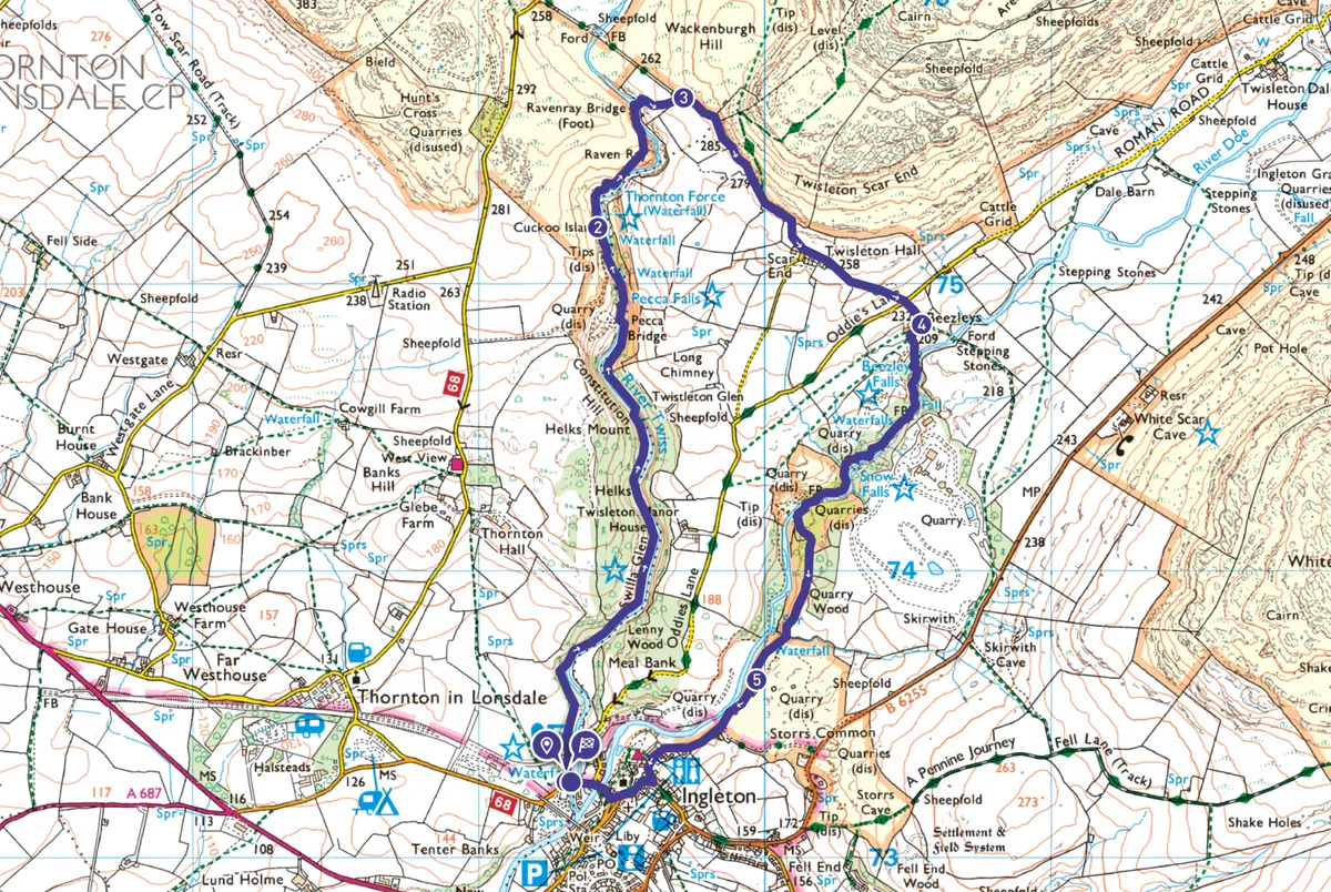
Ingleton Falls walk
4.2 miles / 6.8 km | 3 hours | moderate | 314m ascent
1. Swilla Glen
The route follows a naturally clockwise course from the pay booth and is well signposted. Head off through woodland, passing old tree trunks with coins from over the decades pressed into the bark, making them look like dinosaurs or crocodilians. The outward route follows the western bank of the River Twiss through Swilla Glen.
Enjoy some energetic climbing up and down through Swilla Glen and below Constitution Hill. Look out for autumn colour – hawthorns and hollies in berry, ivy in flower, beech trees, fast changing colour.
Cross the River Twiss in Twistleton Glen and follow the eastern bank northwards to Pecca Bridge. Pecca Falls are particularly impressive with water coming over the three falls with incredible force.
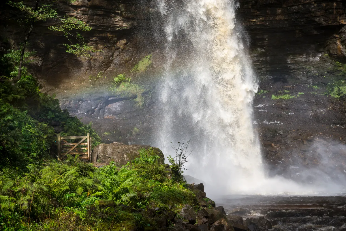
Continue north now back on the western bank, climbing up by Pecca Falls and Hollybush Spout, then following the River Twiss in calmer mood to head past Cuckoo Island. Climb a little to emerge into the open country around Thornton Force.

2. Raven Ray bridge
Continue climbing left of Thornton Force, to emerge into limestone country. Follow the path to cross Raven Ray bridge. Climb up from the River Twiss to join the walled Twistleton Lane below Wackenburgh Hill.

3. Scar End
Turn right with long views to Bowland. Continue on the track, Ingleborough coming into view with perhaps its most impressive aspect. Drop to the farm buildings at Scar End and Twistleton Hall.
A good track winds down to Oddie’s Lane with fabulous views of Ingleborough and White Scar. The quarries of Ingleton are obvious, too. Cross the lane and drop down to the toilets and snack bar at Beezley’s.

4. Snow Falls
Through a gate, rejoin the Waterfalls Walk. Head south alongside the River Doe, descending by Beezley Falls and Triple Spout on the western bank of the river.
Continue to drop down by Rival Falls, the deep pool of Black Hole and then by Baxenghyll Gorge, enjoying glorious cascades.
The path continues down by Snow Falls to emerge into the open in the quarried landscape of Meal Bank Lime Works. This ceased production in 1909.

5. Thacking Lane
The path heads clearly into Ingleton as Thacking Lane, leading into Main Street. Keep right by the church to drop down to cross the two rivers to return to the car park on the right.
Ingleton Falls map
Ingleton Falls walking route and map
Useful information
Starting point
Start at the Waterfalls Walk car park in Ingleton (LA6 3ET) served by bus No.581 from Settle. This walk is on private land for which there is an admission charge, including parking. Check opening times on the Ingleton Waterfalls Trail website before planning your walk.
Terrain
The terrain is a mix of riverside and woodland paths with rocky steps and can be muddy and slippery in parts after heavy rain. It would not be suitable for wheelchairs or pushchairs.
Map
OS Explorer OL2
Eat
The Craven Heifer Inn in Ingleton is good for food, although there are lots of options, including tea rooms and a chip shop.