The Cairngorms is a stirring landscape of towering trees, shimmering lochs and majestic wildlife. The area was designated as a national park in 2003, and later extended in 2010. It is our largest national park – almost twice the size of the Lake District – and home to four of the five highest mountains in Britain.
The Cairngorms National Park is pockmarked with 60 lochs and many more lochans (small lochs), along with more than half the surviving ancient Caledonian forest. A quarter of Britain's threatened animal, plant, insect and fungi species are found in the Cairngorms, some of which are endemic to the park. For unique wildlife, there is nowhere like it.
The many walking trails that thread through the national park offer a great way to explore this stunning countryside. Our guide to the most beautiful walks in the Cairngorms National Park includes route descriptions and maps.

Cairngorms walks
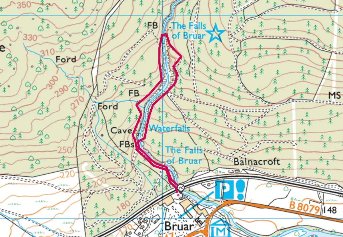
Falls of Bruar, Perth and Kinross
1.2 miles/2km | 1 hours | easy

The dramatic Falls of Bruar are best observed in wet weather conditions. The Cairngorms moors and mountains harness the fallen rain, soak it up like a gargantuan sponge, then, by unseen energies, force it up though the surface of the ground in the form of bubbling streams.
The Bruar Water, just north of Blair Atholl, oozes from the soggy plateaux and moors of the great Atholl Deer Forest and flows gently down the empty miles of Glen Bruar before changing character completely.
Step carefully beneath golden larches, towering Scots pines and over magnificent mountain ash roots in pursuit of this roaring Cairngorms cascade on a 1.2-mile walk.
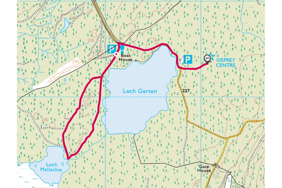
Loch Garten, Highland
2.4 miles/3.8km | 1.5 hours | easy

Hidden within Abernethy Forest in the lowlands of the Cairngorms National Park is Loch Garten. With its ancient Caledonian pine forest, boggy woodland and rich waters, the reserve is an embodiment of the wild and compelling nature of the Scottish Highlands.
Loch Garten's ancient trees, tottering wood-ant nests, soaring ospreys and grazing deer make it one of Scotland's most beautiful nature reserves. Explore the loch on a 2.4-mile walk.
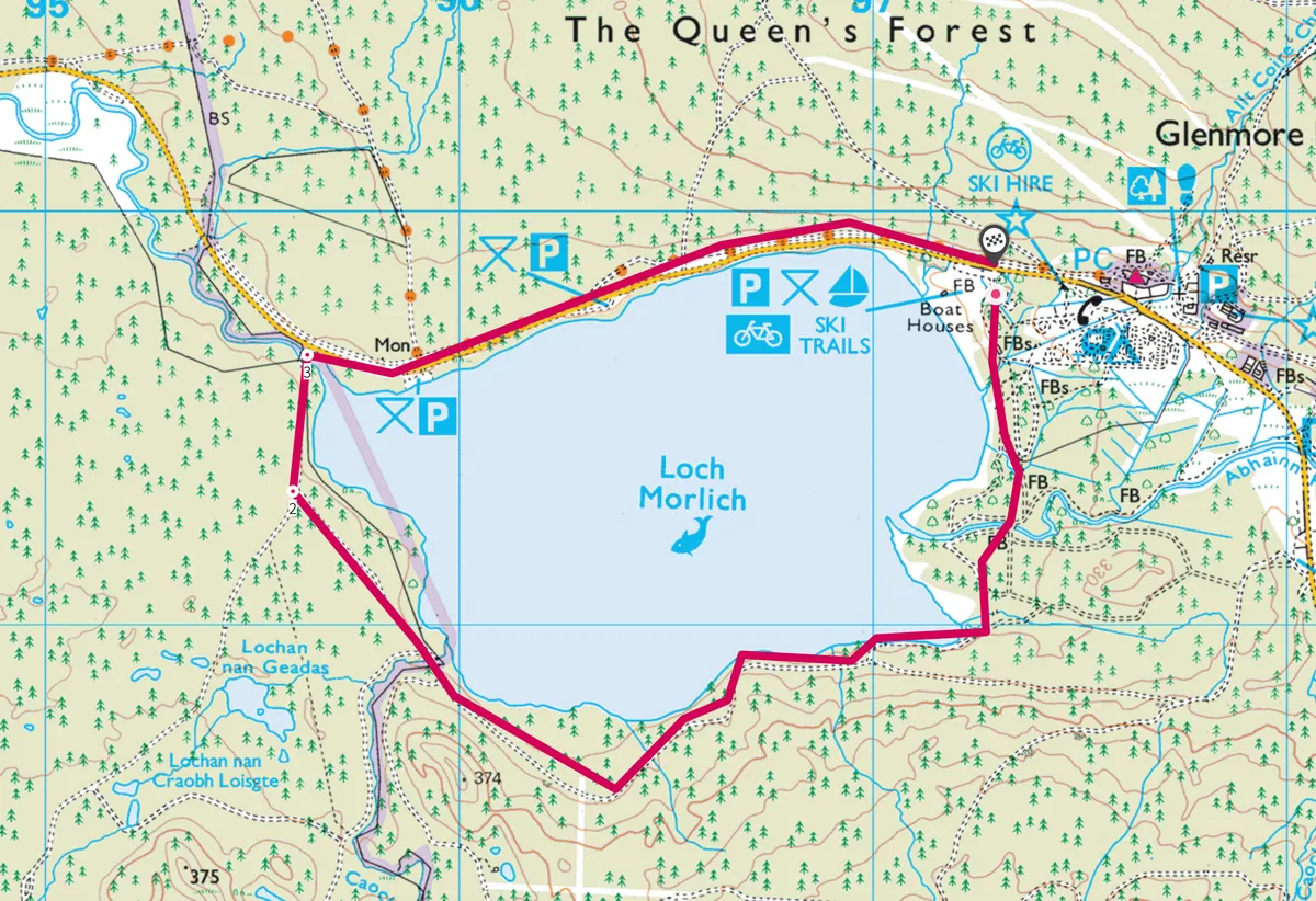
Loch Morlich, Highland
3.1 miles/5km | 2 hours | easy

Bustling Aviemore, with its choice of hip or traditional bars, a good Italian restaurant and swish, hotel-run wooden cabins, is the ideal base for a wintry foray around the northern fringes of the park and its most beautiful lochs – not least Loch Morlich.
There are few lochs in Scotland that have a more picture-perfect surrounding than Loch Morlich. The foreground comprises forests fringed by beaches and backdropped by snow-clad peaks. Circling the loch is a very popular walk among tourists and locals alike.
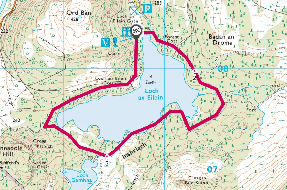
Loch an Eilein, Highland
3 miles/4.9km | 2 hours | easy

After a night in Aviemore, wrap up warm and visit a frozen paradise in the pristine Rothiemurchus Estate, with its 10,000 hectares of ancient forest.
Encircled by mature Scots pine, Loch an Eilein is, for many, the finest short walk in the country. The level three-mile circuit is ideal for youngsters and takes around an hour and a half to complete. Birdlife en route includes wrens, jays and treecreepers.
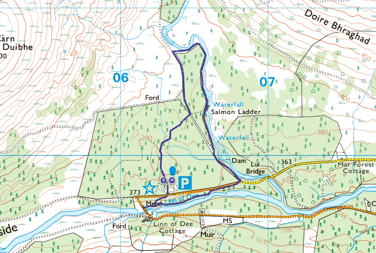
Linn of Dee
2 miles/3.2km | 1.5 hours | easy

Experience the beautiful upper Dee on an easy walk to the spectacular water-carved gorge of the Linn of Dee, before seeking out the captivating short falls on nearby Lui Water. Tourists flock to Braemar and the gorge, and it’s easy to see why when you consider the grand surroundings.
The Highland town of Braemar, solidly built out of Cairngorm granite, has a long history of attracting the country’s titled and powerful. One of the earliest famous visitors was Angus MacFergus, King of the Picts, who built a timber fort at or near where the present Braemar Castle stands.
Glen Tanar Estate, Aberdeenshire
2.9 miles/4.7km |1–2 hours | easy–moderate

Glen Tanar is special at this time of year for the birdlife that inhabits its ancient Scots pinewoods. The Water of Tanar, a tributary of the Dee, flows through this well-managed and protected landscape – a wide valley below the Munro of Mount Keen.
Red squirrels are common here, as are Scottish crossbills; both feed on the pine kernels. This endemic-to-Scotland, Scots pine-dwelling finch has a mellifluous voice: “choo-choo-choo”. Its song is most pronounced when calling excitedly before taking off in wide-ranging flight.
Long-tailed tits, curlews, oystercatchers, peewits and snipe also thrive due to the mixed habitats. A morning walk is the best way to experience this majestic area and to hear the myriad birds that are busy courting.
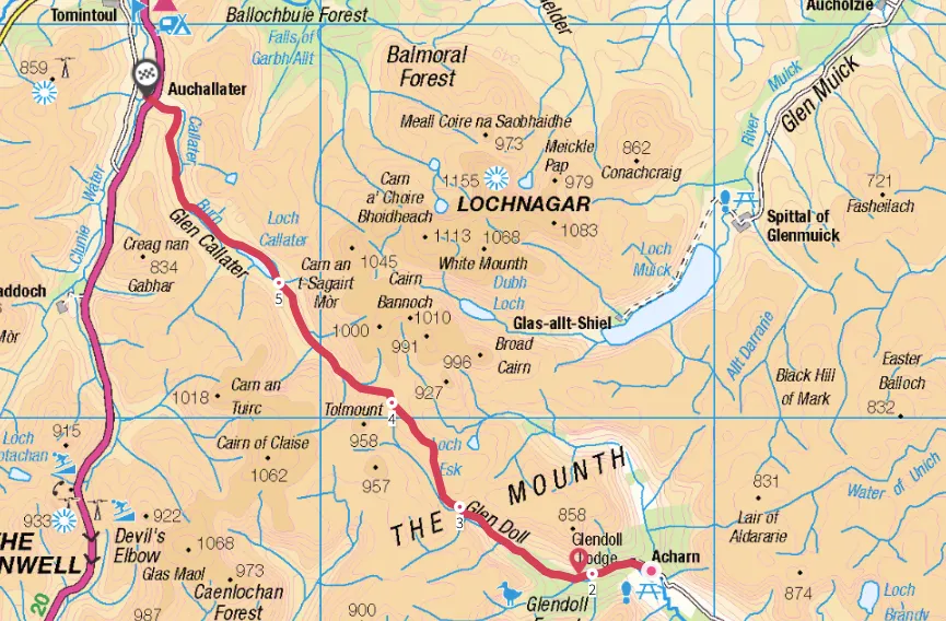
Jock's Road, Angus and Aberdeenshire
13.8 miles/22.2km | 7–8 hours | challenging

Cattle herders of old would have enlivened this high moorland passage with their shouts and curses as they headed south from Aberdeenshire’s highlands to market in neighbouring Angus. By the beginning of the 20th century, routes such as Jock’s Road, that links the village of Braemar to Angus, became largely forgotten byways, used by shepherds and few others.
The landscape it crosses runs from the end of Glen Doll, one of five Angus glens that extend north like fingers, above which rises The Mounth, an open upland area that is part of the Grampian mountains.
Hike across this wild, lonely moorland, alongside turbulent waters and beneath brooding mountains on an age-old trail between Aberdeenshire and Angus you’ll climb more than 1,400m, a height greater than that of Ben Nevis, Britain’s tallest mountain.
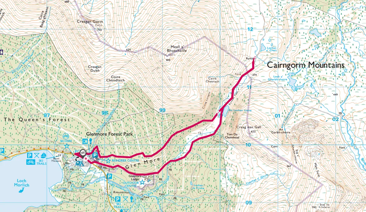
Glenmore Forest Park and Ryvoan pass, Aberdeenshire
5.3 miles/8.6km | 3.5 hours | moderate

Ryvoan Pass is a great introduction to the Cairngorms National Park. Peppered with Scots pine trees, gently wooded slopes give way to a wilder landscape of rocky hills and untamed moor. Many of the park’s more elusive creatures can be found here.
Ancient Caledonian pines form a beautiful walkway leading to the Green Lochan - An Lochan Uaine. A gentle climb leads up the Ryvoan pass, with breathtaking views of Loch Morlich.
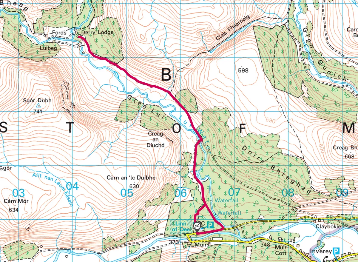
Glen Lui, Aberdeenshire

Discover this historic glen in the Cairngorms National Park, through which the Lui Water tumbles and turns amid the ancient Caledonian Pine Forest.
This accessible route winds through the National Trust for Scotland’s Mar Lodge Estate on the southern edge of the Cairngorms National Park, one of the UK’s last real wildernesses.
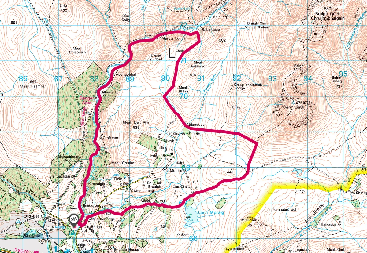
Glen Tilt and loch Moraig, Perthshire
12.3 miles/19.8km | 8 hours | challenging

This 12.3-mile walk from Blair Atholl explores the southern realm of the Cairngorms National Park, passing beneath the summit of Carn Liath before returning through Glen Tilt
The walk can be done in one go or spread over two days with a wild camp overlooking the beautiful and dramatic Glen Tilt. About half of the route uses footpaths and lanes but the other half in trackless, requiring a level of map reading and compass skills.
Carrbridge and Docharn circuit, Highland

Follow a trail of pleasant pinewoods around Carrbridge, stopping to savour this magnificent rushing river and the stone that bridges over it. Carrbridge walking route and map with Walking Highlands.
River Dee, Braemar, Aberdeenshire

A circular walk starting from Braemar takes in the confluence of the two main rivers, the Dee and the Clunie. It then climbs gently through birch woods to return to the centre of the village. River Dee walking route and map with Walking Highlands.
Loch Muick, Aberdeenshire

An unusually level walk in the Cairngorms, around Loch Muick on the Balmoral Estate. The walk provides stunning views of the Scottish scenery. You can also see Glas-allt Shiel house, built by Queen Victoria. Loch Muick walking route and map with Walking Highlands.
Pattack Falls and Druim an Aird, Highland

Take a relaxing amble through varied landscapes, passing the Pattack gorge waterfalls before exploring the ruins of the deserted village of Druim an Aird. Pattack Falls walking route and map with Walking Highlands.


