No tarmac roads cross the rugged Rhinogydd in north-west Wales. Before a coastal route was cut through Barmouth’s rock in the late 18th century, the area west of the mountains could only be reached inland from the south via mountain passes and the valleys of Cwm Ysgethin and Cwm Nantcol.
Packhorse trains, drovers and stagecoaches navigated the green lanes where few venture now. A walk around Moelfre offers a taste of these forgotten ways.

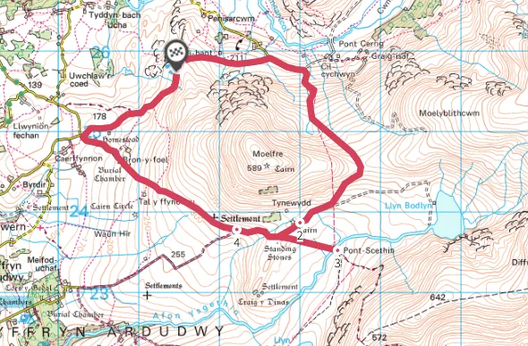
A moderate-challenging circular walk around Moelfre hill in Snowdonia National Park
6.5 miles/10.5km | 4.5 hours | moderate-challenging
1. Up to the saddle
Start from the car park at a viewpoint above peaceful, pastoral Cwm Nantcol. Hemmed in at the far end by the mountains of Rhinog Fach and Rhinog Fawr, the valley’s rocky crags are divided by the deep, narrow chasm of Bwlch Drws Ardudwy. At the lane’s end is Maes-y-garnedd, birthplace of Colonel John Jones, a brother-in-law of Oliver Cromwell. He was one of the signatories of King Charles I’s death warrant and, following the Restoration, Jones himself was executed.
Walk ahead along the lane and, after passing a lane on the left, join the route of Cwm Nantcol’s drovers by taking a path right uphill to a stile. Ascend through wall gaps, with the dark crags of Moelfre to the right. Go through a gate to emerge on the saddle between Moelblithcwm and Moelfre, savouring views of wild, marshy, uninhabited Cwm Ysgethin. Head slightly right downhill to join a firm track and turn right.
Related articles
2. Drop to the bridge
Close to a coniferous plantation lies ruined Ty Newydd, said to be a drovers’ and stagecoach inn subject to many bandit raids. A track on the left drops to lonely Pont Scethin, a low hump-backed bridge spanning Afon Ysgethin. The crossing was used by stagecoaches on their journeys between London and Harlech after traversing the formidable ridge in front of you.

3. Fort diversion
Return to the higher track and, just before it, look for two low standing stones on your left. From here it is possible to take a diversion across boggy ground to Craig y Dinas Iron Age hillfort, with its imposing ramparts and remains of roundhouses below to the west. Back on the main track, turn left and, just before a gate across it, go through a gate on the right to continue along the old road.
4. Healing well
You will soon pass the footings of a settlement on your right. Keep ahead through gates and look out for the remains of a Neolithic burial chamber with a large slipped capstone in a left-hand wall. Veer left before Bron y Foel to a lane junction and turn right.
About 300 yards before the car park, enjoy your last dip into history by taking a small gate on the left. It was here that St Enddwyn was cured of a ‘sore disease’ by bathing in the spring, which soon became a renowned healing well for many ailments.
Cwm Nantcol and Cwm Ysgethin walking route and map