The Otterburn Ranges cover 90 square miles of the Northumberland National Park, and have been used by the military since 1911.
The Otterburn Ranges comprise some of the most remote upland areas in the UK, and include several working farms. When military exercises are in progress, the hoisting of red flags around the boundaries indicates restricted access, but at other times, visitors are welcome to drive or walk on the ranges, provided they remain on roads or marked footpaths. Limited access has meant that wildlife, particularly birds, have been able to flourish here, and there’s a chance you may see the rare courtship ritual between male black grouse, known as a lek.
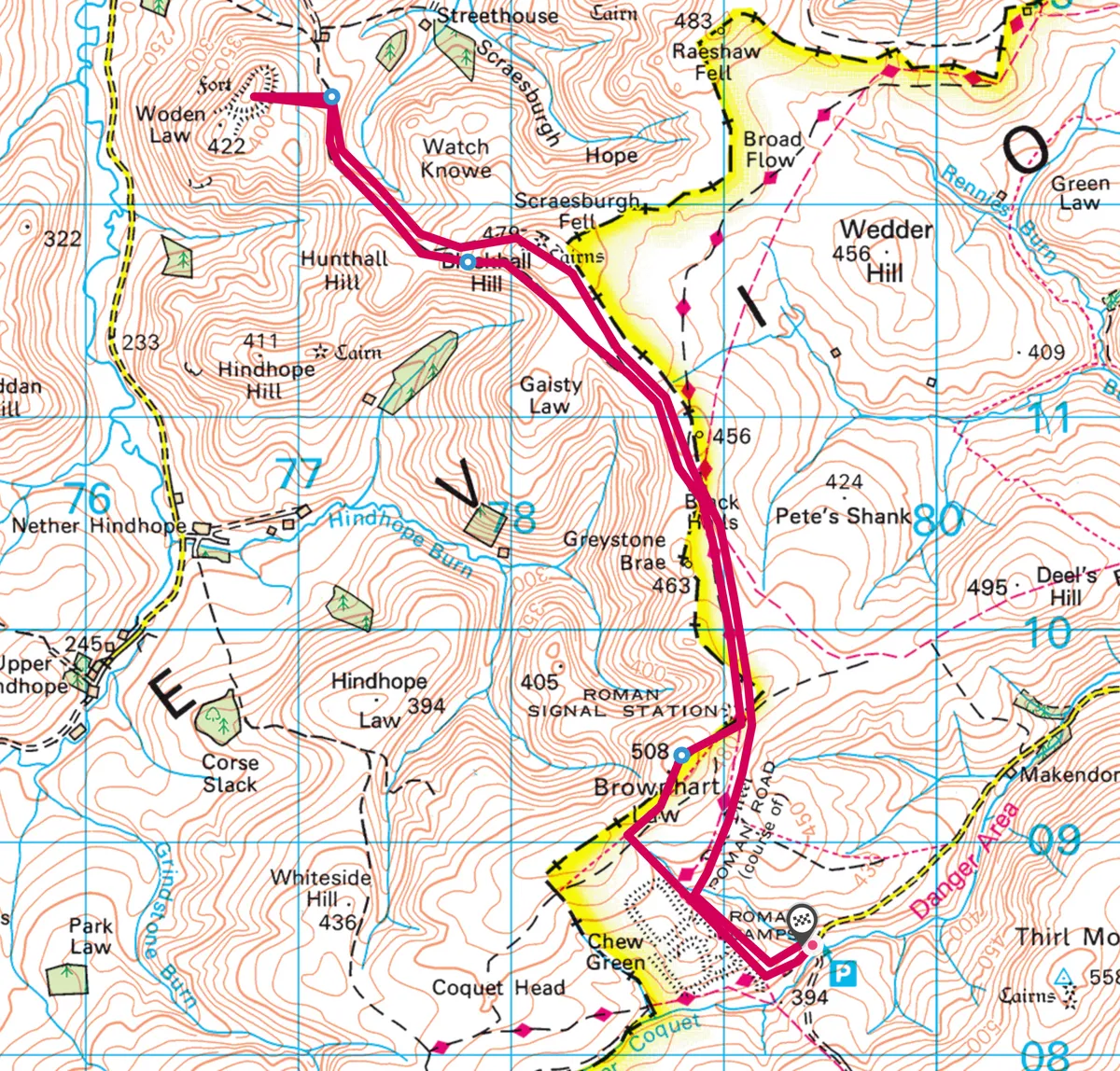
Follow this high-level 8.2-mile walking route in the Otterburn Ranges in Northumberland.

1
Brownhart summit
From the bridge below the car park, follow the track uphill to a signpost and continue to the grass-covered remains of the Roman fort of Chew Green. Continue to the next signpost and head directly uphill to join the border fence. Turn right and follow this to the summit of Brownhart Law. From here there are extensive views east to The Cheviot and north into Scotland.

2
Into Scotland
Continue downhill and over a stile. Go through a gate in the border fence into Scotland and follow the track through heather and over Greystone Brae to a larger gate.
From here, the course of the Roman Dere Street leads along the broad ridge, where you are likely to see small herds of feral goats grazing across the hillside. Birds that you might also see include skylark, meadow pipit, lapwing, curlew, buzzard and merlin.
Swing left at the next gate and go up the final short slope to Blackhall Hill summit, which is crowned by ancient tumuli. As befits the highest point of the walk, the views from here are wonderful, across the surrounding hills and down into the valleys.

3
The Law
Descend over a short but steep craggy section and on to a gate. Go through this and down to the next low point, where another gate leads to a track that takes you to the summit of Woden Law. Here are the remains of a very extensive hillfort, which is much more impressive and sharply defined than Chew Green.
4
Descend to the end
Retrace your route to the second gate, and rather than reascending Blackhall Hill, skirt round below the crags and rejoin the Dere Street track beyond. Follow this through the gate and around the sides of Greystone Brae and Brownhart Law, and over a wooden bridge to Chew Green. Descend to the car park.
Map
Click on the map below for an interactive versions of the route.
Useful Information
TERRAIN
Mountain footpaths, some of them boggy. Windswept hills – boots and windproof clothing are necessary.
HOW TO GET THERE
By car: Take the B6341 west from Rothbury for 4 miles, then turn right on a minor road through Alwinton and Barrowburn. The car park is approx 6 miles west of Barrowburn. If the red flags are not flying, the car park can be reached via the A68 to Redesdale Camp, then via the minor road across the MOD range.
REFRESHMENTS
Rose and Thistle Inn
Alwinton, Morpeth NE65 7BQ
01669 650226
roseandthistlealwinton.com